 The ramp is a challenge but once up on the Bridge the
views may be worth the climb and the down hill on the other side is
fun. Watch out for pedestrians, blind corners and speeding cyclists.
The ramp is a challenge but once up on the Bridge the
views may be worth the climb and the down hill on the other side is
fun. Watch out for pedestrians, blind corners and speeding cyclists. See Map on Bikely.
A bike ride around the foreshores and back streets and parks of the Inner West is a good way to see scenic and historic areas of Leichhardt, Glebe and Balmain. This one starts at Moores Cafe, in Moore St, Leichhardt, because that is where LBUG meets for its regular Sunday rides. Follow the green route on the maps. Red routes are some options you could also explore.
After a coffee, head east on Moore St and turn right at Catherine St. Proced along and turn left on Albion St, just before Parramatta Rd.. Opposite Maquarie St, look for a left onto Whites Creek Lane. There is a bicycle logo to mark the start. Follow the lane, which takes a curvy route along the line of the old creek way, watching for local resident's cars and for trucks (still some factories along here) and some rough bits of road, until a bicycle crossing at Styles St (take care here as cars often speed down the hill towards the crossing). Cross over and follow the lane again, this time going under Booth St. The path now goes through a park and across a wetland the Council has installed to clean the water from the creek. Just why the bike path needed to go right through the middle is another story.
Where the path comes out at Piper St do a dog leg left/right and cross over. The path continues on the other side of the creek down to Brenan St. Turn right here (becomes Railway Pde) and follow along to an underpass of the Light Rail Way, through a pocket park to The Crescent, a busy road connecting to the City West Link. Go right (southeast) along the shared footpath to Johnston St, Annandale. Cross The Crescent at the lights onto Chapman Rd and head into Bicentennial Park on the waterfront of Rozelle Bay.
Follow the path behind the children's playground and then across the timber bridge over Johnston Ck Canal and take any of the paths across the Glebe side of the Park towards Glebe Point, at the north end of Glebe Point Rd. The new foreshore path continues right around the edge of Blackwattle Bay to the SU Rowing Club at end of Ferry Rd. Go right up Ferry Rd and turn left at Taylor St past Glebe High School, to the lights at Pyrmont Bridge Rd. The path will eventually be extended in front of the High School to avoid Taylor St, but it is not busy.
For the heritage minded, note the old sandstone docks and cranes along the first bit of the path and the collonade leading to remains of an incinerator designed by Walter Burley Griffin nearer Ferry Rd.
A litlle bit of cycle route history here too. Before the foreshore path was finished in 2006 cyclists used to go via Leichhardt St, then on a path between two blocks of flats to Cook St and another narrow path leading to Sheehy St and then to Forsyth and Tayor St. You can still do this if the number of pedestrians and dogs is too much to bear.
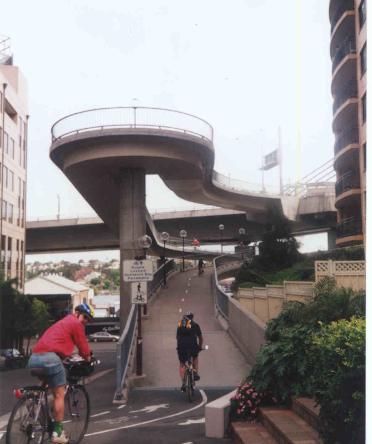
Back at Bridge Rd, turn left here and depending on traffic (usually light on Sundays) use the road or the footpath (southern side is wider) along to the Fish Market. Here you can have a break or lunch then exit through the car park to Banks St, under the Western Distributor fly-over. Look for Saunders St, which joins Miller St near Banks St. (To help navigation, look for Channel 10 HQ in Saunders St.) Go up Saunders St to the large Meriton apartment block at the end. On the left you will see a ramp leading up on to the Anzac Bridge pedestrian and cycle-way. Cross road with care, looking for cars AND cyclists.
The ramp is a challenge but once up on the Bridge the
views may be worth the climb and the down hill on the other side is
fun. Watch out for pedestrians, blind corners and speeding cyclists.
Over the bridge the cycleway continues to the junction with Victoria Rd and then does a sharp right on to the Victoria Rd footpath. Again, watch for other cyclists and pedestrians on the blind corner and past the narrow space behind the bus shelter (someone will move the bus shelter to a more sensible spot one day! See News and Issues). You can also turn sharp left over a new pedestrian/cyclebridge over the CWL, if heading back to Annandale or Leichhardt.
At Robert St, cross over using the lights and turn right then immediately left on Crescent St. This is the start of a back street route up to Balmain, along Crescent St, Moore St, Goodsir St, Evans St and Beattie St. The roads are narrow so best to "take the lane" where you can, particularly on Beattie St, and don't allow impatient motorists to squeeze past. Balmain is a 40 K zone but not everyone knows it!
Beattie St comes out in Balmain at Loyalty Square, near Woolies and the Vanity Fair pub. Stop for a look around, food or a beer and then cross Darling St and go down Mort St (past the ANZ bank). Follow Mort St all the way down to the waterfront. The Thames St Ferry wharf is there, and to the left is Mort Bay Park. The old docks have historic early shipping and wartime significance.
Cross the park to Yeend St and wend your way up to Ballast Point Rd and Wharf Rd, where there are some fine old houses. Head west on Wharf Rd and come out at Birchgrove Oval on Grove St. You could detour to Louisa Rd and Yurulbin Point for some more harbour views, or continue past the Oval to Cove St and Birchgrove Rd. Head south past Birchgrove Public School and take a right down Glassop St. There are more views of the Harnbour and Cockatoo Island from the cliffs above the Dawn Fraser Pool and from Elkington Park.
Back on Glassop St, which becomes Terry St near Balmain High School, follow along past the Harbour Shores housing estate and take a right turn at Margaret St. This leads to a long ramp down to the foreshore and a shared path which goes around Iron Cove. There are some remains of the old Balmain power house here.The path goes under the Iron Cove Bridge, past King George V Park and past Callan Park (Rozelle Hospital), the rowing club at foot of Glover St and Leichhardt Pool to Hawthorne Canal at the Lilyfield Rd bridge, which is now closed to motor traffic.
From here as an optional extension you can do the rest of the Bay Run route past the UTS rowing club to Timbrell Drive and Henley Marine Drive, and complete the circuit back over the Iron Cove Bridge, descending to the foreshore path via a stair way at the southeast end of the bridge. Rather than doing a circuit, some cyclists prefer to turn around at the Drummoyne Rowing Club and come back along Henley Marine Drive. This avoids the narrow footpath and awkward connections on the Iron Cove Bridge. There are also further extensions to Gladesville Bridge via Renwick St and Collingwood St in Drummoyne. (See map 2)
If not doing the Bay Run route, head south along the Hawthorne Canal about 500 m to a pedestrian underpass of the railway line, which brings you to Darley Rd. At the roundabout on Darley Rd head up Allen St (short sharp hill here) back to Norton St in Leichhardt, where there are many cafes, or continue across Norton St on Allen St to Derbyshire Rd (behind the High School), to Moore St West (currently blocked due to construction of a playing field - use path through school at end of Allen St ) and do a dog leg across Balmain Rd to Moore St and back to Moores Cafe.